
1931 Medina Pictorial Map of Mexico 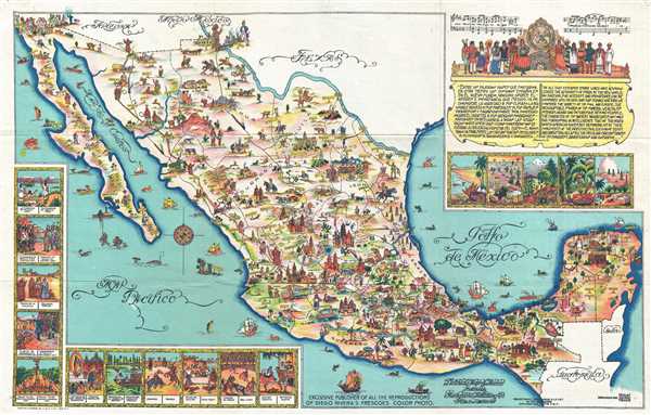 WE SELL ONLY ORIGINAL ANTIQUE MAPS - NOT REPRODUCTIONS Title: Pictorial Map of Mexico. Description: This is a 1931 Miguel Gomez Medina pictorial map of Mexico. The map depicts all of Mexico from the southern United States (labeling Arizona, New Mexico, and Texas) to the Belize, Guatemala, and the Pacific Ocean and from the Pacific Ocean and Baja California to the Gulf of Mexico. Wonderfully composed, countless tiny cartoon vignettes illustrate Mexican life, history, and culture. Numerous cities are labeled, including Mexico City, Chihuahua, Oaxaca, Ciudad Juarez, and Tijuana, among others. The modern tourist haven of Cozumel Island is also illustrated. Chichén Itzá, the astounding Mayan ruin in the Yucatan is illustrated in profile. At the U.S.-Mexico border, Uncle Sam appears El Paso, Texas, on one end of a bridge a bridge, while a good natured Mexican citizen offers what is possibly a bottle of tequila, from the Mexican side of the river. In the ocean, numerous fish and other sea creatures are illustrated, along with various ships. Several vignettes are situated along the left and bottom border, illustrating aspects of Mexican history and culture. Each of the vignettes is captioned in both Spanish and English and features scenes of the founding of Mexico, the conquest of Mexico by Cortes, Mexican independence, and cultural events such as a rodeo, a bull-fight, and the national dance. A cartouche in the upper right corner contains a quote from William Prescott stating the splendor and unequaled importance of Mexico to the Spanish empire. Below the quote are five beautifully drawn landscapes. This map was created in 1931 by Miguel Gomez Medina, the best known Mexican artist creating pictorial maps, and published by Fischgrund Publishing Company. There are at least two editions of this map, the present medium format example, and another larger format edition. Size: Printed area measures 12.5 inches high by 20 inches wide. Condition: Very good. Verso repair of a fold separation. Blank on verso. Shipping: Shipping rates are not negotiable. Items are shipped within three business days of receiving payment. We are happy to consolidate shipping where possible. The following shipping options are available: 1. FedEx Overnight (45 USD). USA Only. Signature Required. Customs: International buyers are responsible for paying duty and taxes on delivery. DHL or FedEx will contact the buyer by telephone to arrange tax payment if it is levied. Duty varies by country and we cannot predict the amount you will be charged. Some countries are duty free, others are not. Typically, a customs duty and/or VAT tax will be assessed on all parcels to continental Europe. Sometimes duty or tax is due in China, but is seems very random. Hong Kong, Singapore, Korea, and Taiwan have never assessed duty on a map we shipped. Maps shipped to the UK should be duty free as educational materials, but from time to time duty of 5% is assessed incorrectly by the UK customs agents. Insurance: All shipments are insured privately against loss and damage. All of our shipments require a signature for insurance purposes. If you have any questions please feel free to email us through eBay. Other Services Conservation Framing: Geographicus recommends basic conservation framing services for any antique paper. We do not offer this service. |

" class="zoomMainImage swiper-slide">
1931 Medina Pictorial Map of Mexico WE SELL ONLY ORIGINAL ANTIQUE MAPS - NOT REPRODUCTIONS Title: Pictorial Map of Mexico. Description: This is a 1931 Miguel Gomez Medina pictorial map of Mexico. The map depicts all of Mexico from the southern United States (labeling Arizona, New Mexico, and Texas) to the Belize, Guatemala, and the Pacific Ocean and from the Pacific Ocean and Baja California to the Gulf of Mexico. Wonderfully composed, countless tiny cartoon vignettes illustrate Mexican life, history, and culture. Numerous cities are labeled, including Mexico City, Chihuahua, Oaxaca, Ciudad Juarez, and Tijuana, among others. The modern tourist haven of Cozumel Island is also illustrated. Chichén Itzá, the astounding Mayan ruin in the Yucatan is illustrated in profile. At the U.S.-Mexico border, Uncle Sam appears El Paso, Texas, on one end of a bridge a bridge, while a good natured Mexican citizen offers what is possibly a bottle of tequila, from the Mexican side of the river. In the ocean, numerous fish and other sea creatures are illustrated, along with various ships. Several vignettes are situated along the left and bottom border, illustrating aspects of Mexican history and culture. Each of the vignettes is captioned in both Spanish and English and features scenes of the founding of Mexico, the conquest of Mexico by Cortes, Mexican independence, and cultural events such as a rodeo, a bull-fight, and the national dance. A cartouche in the upper right corner contains a quote from William Prescott stating the splendor and unequaled importance of Mexico to the Spanish empire. Below the quote are five beautifully drawn landscapes. This map was created in 1931 by Miguel Gomez Medina, the best known Mexican artist creating pictorial maps, and published by Fischgrund Publishing Company. There are at least two editions of this map, the present medium format example, and another larger format edition. Size: Printed area measures 12.5 inches high by 20 inches wide. Condition: Very good. Verso repair of a fold separation. Blank on verso. Shipping: Shipping rates are not negotiable. Items are shipped within three business days of receiving payment. We are happy to consolidate shipping where possible. The following shipping options are available: 1. FedEx Overnight (45 USD). USA Only. Signature Required. Customs: International buyers are responsible for paying duty and taxes on delivery. DHL or FedEx will contact the buyer by telephone to arrange tax payment if it is levied. Duty varies by country and we cannot predict the amount you will be charged. Some countries are duty free, others are not. Typically, a customs duty and/or VAT tax will be assessed on all parcels to continental Europe. Sometimes duty or tax is due in China, but is seems very random. Hong Kong, Singapore, Korea, and Taiwan have never assessed duty on a map we shipped. Maps shipped to the UK should be duty free as educational materials, but from time to time duty of 5% is assessed incorrectly by the UK customs agents. Insurance: All shipments are insured privately against loss and damage. All of our shipments require a signature for insurance purposes. If you have any questions please feel free to email us through eBay. Other Services Conservation Framing: Geographicus recommends basic conservation framing services for any antique paper. We do not offer this service. |
" alt="Carte picturale officiel du Mexique 1931 Médina" width="527" height="527" />
Carte picturale officiel du Mexique 1931 Médina
Carte picturale officiel du Mexique 1931 Médina, Carte picturale du Mexique 1931 Médina authentique
€342.53
SKU: 827704
Colour
"
1931 Medina Pictorial Map of Mexico
WE SELL ONLY ORIGINAL ANTIQUE MAPS - NOT REPRODUCTIONS
Title: Pictorial Map of Mexico.
Description: This is a 1931 Miguel Gomez Medina pictorial map of Mexico. The map depicts all of Mexico from the southern United States (labeling Arizona, New Mexico, and Texas) to the Belize, Guatemala, and the Pacific Ocean and from the Pacific Ocean and Baja California to the Gulf of Mexico. Wonderfully composed, countless tiny cartoon vignettes illustrate Mexican life, history, and culture. Numerous cities are labeled, including Mexico City, Chihuahua, Oaxaca, Ciudad Juarez, and Tijuana, among others. The modern tourist haven of Cozumel Island is also illustrated. Chichén Itzá, the astounding Mayan ruin in the Yucatan is illustrated in profile. At the U.S.-Mexico border, Uncle Sam appears El Paso, Texas, on one end of a bridge a bridge, while a good natured Mexican citizen offers what is possibly a bottle of tequila, from the Mexican side of the river. In the ocean, numerous fish and other sea creatures are illustrated, along with various ships.
Several vignettes are situated along the left and bottom border, illustrating aspects of Mexican history and culture. Each of the vignettes is captioned in both Spanish and English and features scenes of the founding of Mexico, the conquest of Mexico by Cortes, Mexican independence, and cultural events such as a rodeo, a bull-fight, and the national dance. A cartouche in the upper right corner contains a quote from William Prescott stating the splendor and unequaled importance of Mexico to the Spanish empire. Below the quote are five beautifully drawn landscapes.
This map was created in 1931 by Miguel Gomez Medina, the best known Mexican artist creating pictorial maps, and published by Fischgrund Publishing Company. There are at least two editions of this map, the present medium format example, and another larger format edition.
Size: Printed area measures 12.5 inches high by 20 inches wide.
Condition: Very good. Verso repair of a fold separation. Blank on verso.
Shipping: Shipping rates are not negotiable. Items are shipped within three business days of receiving payment. We are happy to consolidate shipping where possible. The following shipping options are available:1. FedEx Overnight (45 USD). USA Only. Signature Required.
2. FedEx Ground or Home Delivery (15 USD). USA Only. 1 - 10 days. If your address is a P.O. Box and cannot ship FedEx we will ship USPS Priority and, while we ship promptly, recent postal personnel cutbacks mean that delivery may take time. Signature Required.
3. FedEx International or DHL International EXPRESS (45 USD).
4. We can use your FedEx Account.
Customs: International buyers are responsible for paying duty and taxes on delivery. DHL or FedEx will contact the buyer by telephone to arrange tax payment if it is levied. Duty varies by country and we cannot predict the amount you will be charged. Some countries are duty free, others are not. Typically, a customs duty and/or VAT tax will be assessed on all parcels to continental Europe. Sometimes duty or tax is due in China, but is seems very random. Hong Kong, Singapore, Korea, and Taiwan have never assessed duty on a map we shipped. Maps shipped to the UK should be duty free as educational materials, but from time to time duty of 5% is assessed incorrectly by the UK customs agents.
Insurance: All shipments are insured privately against loss and damage. All of our shipments require a signature for insurance purposes.
If you have any questions please feel free to email us through eBay.
Other ServicesConservation Framing: Geographicus recommends basic conservation framing services for any antique paper. We do not offer this service.
Antique Map Restoration: Geographicus can repair and restore your antique map. Services include deacidification cleaning flattening and backing.
BEWARE anyone attempting to contact you, from a different eBay account, claiming to represent Geographicus Antique Maps. My eBay handle is GeographicusMaps. If you are contacted by email by someone offering you my items, please call me directly to be certain you are not dealing with a con artist." alt="Carte picturale officiel du Mexique 1931 Médina" width="52" height="52" >
Personalised:: ( x )Personalisation:EditRemove PersonalisationAvailable From:
Buy now.
Pay later.
Earn rewards
Representative APR: 29.9% (variable)
Credit subject to status. Terms apply.
Missed payments may affect your credit score
FrasersPlus
Available Products
SIMILAR ITEMS
- Carte picturale du Mexique 1931 Médina
- Etole XXL - ERIC BOMPARD - 100% Cachemire - Bleu montagne - Neuve !
- Montre de poche chasseur voyageur Elgin 7 bijoux or 14 carats rugissant années 20 1921
- Outil de mesure PRO Metric SAE TÉLESCOPING JAUGE DE TRAM ALUMINIUM SÉTEND JUSQUÀ 10 PIEDS
- Boîte de 3200 pièces de Buster Posey - San Francisco Giants - Seulement 0,10 $ par carte
- Haut corset Drindl D&G Dolce & Gabbana F/W 2002
- J.W. van Henten The Books of the Maccabees (Poche)
- Baskets Givenchy G Move cuir et daim détail 4G
- Authentique boîtier de montre Rolex Date 34 mm Oyster acier complet réf 15000 série 9,4
- Ensemble de golf homme XXIO LeCoq avec sacoche Flex R Caddy.
Back to top