
1814 Thomson Map of Switzerland with View of Mont Blanc 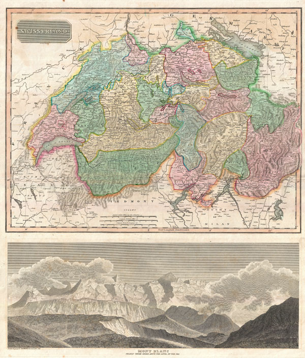 WE SELL ONLY ORIGINAL ANTIQUE MAPS - NOT REPRODUCTIONS Title: Swisserland. Mont Blanc Nearly Three Miles Above the Level of the Sea. Description: This is an excellent example of John Thomsons 1814 map of Switzerland according to its division into 26 constituent Cantons under the 1648 Treaty of Westphalia. Features a splendid view of Mont Blanc in the lower quadrants. This is the first edition of Thomsons map of Switzerland from the 1814 edition of the General Atlas. Subsequent editions of Thomsons General Atlas were published in 1817 and 1826. Size: Printed area measures 24 inches high by 20 inches wide. Condition: Very good condition. Original centerfold exhibits some verso repair and reinforcement. Blank on verso. Shipping: Shipping rates are not negotiable. Items are shipped within three business days of receiving payment. We are happy to consolidate shipping where possible. The following shipping options are available: 1. FedEx Overnight (45 USD). USA Only. Signature Required. Customs: International buyers are responsible for paying duty and taxes on delivery. DHL or FedEx will contact the buyer by telephone to arrange tax payment if it is levied. Duty varies by country and we cannot predict the amount you will be charged. Some countries are duty free, others are not. Typically, a customs duty and/or VAT tax will be assessed on all parcels to continental Europe. Sometimes duty or tax is due in China, but is seems very random. Hong Kong, Singapore, Korea, and Taiwan have never assessed duty on a map we shipped. Maps shipped to the UK should be duty free as educational materials, but from time to time duty of 5% is assessed incorrectly by the UK customs agents. Insurance: All shipments are insured privately against loss and damage. All of our shipments require a signature for insurance purposes. If you have any questions please feel free to email us through eBay. Other Services Conservation Framing: Geographicus recommends basic conservation framing services for any antique paper. We do not offer this service. |

1814 Thomson Map of Switzerland with View of Mont Blanc WE SELL ONLY ORIGINAL ANTIQUE MAPS - NOT REPRODUCTIONS Title: Swisserland. Mont Blanc Nearly Three Miles Above the Level of the Sea. Description: This is an excellent example of John Thomsons 1814 map of Switzerland according to its division into 26 constituent Cantons under the 1648 Treaty of Westphalia. Features a splendid view of Mont Blanc in the lower quadrants. This is the first edition of Thomsons map of Switzerland from the 1814 edition of the General Atlas. Subsequent editions of Thomsons General Atlas were published in 1817 and 1826. Size: Printed area measures 24 inches high by 20 inches wide. Condition: Very good condition. Original centerfold exhibits some verso repair and reinforcement. Blank on verso. Shipping: Shipping rates are not negotiable. Items are shipped within three business days of receiving payment. We are happy to consolidate shipping where possible. The following shipping options are available: 1. FedEx Overnight (45 USD). USA Only. Signature Required. Customs: International buyers are responsible for paying duty and taxes on delivery. DHL or FedEx will contact the buyer by telephone to arrange tax payment if it is levied. Duty varies by country and we cannot predict the amount you will be charged. Some countries are duty free, others are not. Typically, a customs duty and/or VAT tax will be assessed on all parcels to continental Europe. Sometimes duty or tax is due in China, but is seems very random. Hong Kong, Singapore, Korea, and Taiwan have never assessed duty on a map we shipped. Maps shipped to the UK should be duty free as educational materials, but from time to time duty of 5% is assessed incorrectly by the UK customs agents. Insurance: All shipments are insured privately against loss and damage. All of our shipments require a signature for insurance purposes. If you have any questions please feel free to email us through eBay. Other Services Conservation Framing: Geographicus recommends basic conservation framing services for any antique paper. We do not offer this service. |
